











California’s Death Valley offers a wide variety of things to see within its expanses. Carole Jacobs, Real Food Traveler’s Health & Fitness Editor, offers a different glimpse – through its canyons. As a bonus, Carole also provides suggestions for how to get there and where to stay while exploring each of six areas.

Save this handy article to Pinterest to help you plan your trip to Death Valley. Images courtesy of Pixabay, Unsplash, Flickr and Carole Jacobs. Graphic by RealFoodTraveler.com.
Romancing the Canyons: A Journey Through 6 of Death Valley’s Secret Kingdoms
Death Valley may be synonymous with desert flats, but the real magic lies in its canyons.
Whether narrowing into twisting corridors or expanding into a labyrinth of chasms, each canyon is a world unto itself- a passage into Death’s Valley geologic, geographic, and cultural past. Step inside a canyon’s inner sanctum, and you may find anything from bubbling springs to barren badlands, petroglyphs that tell stories of ancient civilizations to fossils that foretell the end of time.
With hundreds of canyons from which to choose, where to start? You can’t go wrong with the following six, all of which reveal some of Death Valley’s most closely held secrets.
Note: Winter storms can temporarily close roads into the canyons. Visit Death Valley’s road closure website for up-to-date info.
Hungry for more? Read Carole’s article about Death Valley Super Blooms.
1. Surprise Canyon, Panamint Mountains
The last thing I expected to find at the end of an 8-mile road through bone-dry desert was water.
But the steep, rugged canyon at road’s end yielded its namesake surprise: Seven waterfalls tumbling hundreds of feet over a series of cliffs, buttresses, and chasms to a tangle of leafy cottonwoods, wildflowers, and mosses on the canyon floor.
A rugged 2-mile trail pushed up the craggy slope to Limekiln Spring, the source of the desert oasis.
Between the cascades bolting down the trail and pools collecting in the few flat spots, it was more of a swim than a hike up to the spring. Less than five minutes in, I abandoned all efforts to keep my boots dry and resigned myself to the inevitable. By the time I reached Limekiln an hour later, I was one with the spring–totally drenched.
Talk about the little spring that could: Bubbling from the steep canyon walls, it sends hundreds of gallons of water a minute downstream. Every rock, cliff, desert bloom and blade of grass below it was dripping wet, while everything above it was parched and desolate—a landscape only a rattlesnake could love.
Above the spring, the trail pushed up through spiky desert scrub, becoming increasingly faint and so steep I had to climb on all fours. Pausing to catch my breath, I scanned the canyon above me for remnants of the tortuous 5.5-mile route miners had chiseled and blasted from the sheer rockface in the 1870s to reach Panamint City, a mining camp perched several thousand feet above on the distant summit.
All I saw was some rusted hubcaps and what looked like the remains of a rear axle—not a good sign.
A rattle in the brush sealed my decision: The only way I was going to see Panamint City was virtually.
In the photo in my guidebook, the dilapidated ruins of Panamint City seemed to rise like a mirage from a high- altitude bowl of pinion and juniper. Once called “the toughest, meanest, most hard-boiled little hellhole that ever passed for a civilized town,” Panamint City yielded $2.5 million in silver in 1873 before going bust in 1877. More than 150 years later, Panama City’s remote location has rendered it the best-preserved ghost town in the West, and the most isolated.
Today, the dusty remains include several abandoned miners’ cabins, more recently repurposed as crash pads for backpackers, who named the largest cabin “Panamint Hilton” for its running water, glass windows, wind chimes, and working fireplace. Other relics include a hillbilly hot tub MacGyvered from a bathtub; the rusted remains of old bars and saloons; trash sculptures; mining tunnels; and the rotting carcasses of several trucks and cars, including a 1957 Chevy with the bumper sticker, “I’d rather be in Panamint City.”
It’s a fitting tribute, considering there’s no longer any way for the ‘57 to get down. In 1984, a major storm scoured Surprise Canyon and wiped out the road, ending the steady stream of jeepers who had been winching their one-ton trucks up the dry cascading falls to reach Panamint City. A few got away, and still RIP in the canyon.
Directions: From Highway 178 in the Panamint Valley, take Ballarat Road 3.5 miles to the ghost town of Ballarat, turn left on Indian Ranch Road, and follow one mile to Surprise Canyon Road. Turn right and follow four miles to the trailhead. You’ll need a high clearance vehicle for the drive. My Subaru Forester did fine.
Information: Bureau of Land Management Ridgecrest Field Office
Lodging: Panamint Springs Resort: Located about 30 miles from Surprise Canyon, this small, rustic western-style resort located 10 miles inside the western edge of Death Valley National Park on California Scenic Highway 190 overlooks dramatic views of distant sand dunes and the soaring 11,000-foot Panamint Mountains. It offers lodging, camping and RV services, a restaurant and bar famous for its angus beef burgers and craft beers, and a gas station with a general store. The resort overlooks dramatic views of distant sand dunes and the soaring 11,000-foot Panamint Mountains.

Waterfalls in Surprise Canyon. Photo courtesy Flickr.
2. Darwin Canyon, Panamint Springs
Just a stone’s throw west from Panamint Springs Resort is Darwin Canyon, another breathtaking desert oasis with one of the highest waterfalls in Death Valley (80 feet), nine smaller cascades, deep, dark pools, and a stream that races through a boulder-choked gorge, all fed by springs in high ravines.
From Highway 190, I hiked a 2.5-mile dirt road through desert scrub to the trailhead (storm damage has temporarily closed the road to vehicles), then followed the trail along a gentle stream that winded into a narrow, dim-lit canyon flanked by soaring walls.
Less than a half mile in, the trail left the desert in the dust and pushed through dense thickets of willows. Wildflowers bloomed in puddles of sun: yellow princes’ plume, orange globemallow, golden evening primrose, yellow monkeyflower, and white desert prickle poppy.
The vegetation was so dense I heard before I saw Darwin Falls. The misty cascade dropped eighteen feet over a slanted wall and plunged into a shallow pool fringed by ferns.
An easy climb up and around the falls led to a viewpoint of three more falls, including an 80-foot-high cascade that sprayed down a chute into a pile of boulders.
From here, the trail scrambled up sparse footpaths to several waterfalls tucked in narrow ravines, some with startling drops and overlooks. Each one lorded over a private wilderness of cliffs, crags, and grottoes. Even though I was soaked to the hips. I had to remind myself I was in Death Valley and not Yosemite.
Directions: Follow Route 190 to Panamint Springs Resort. One mile west, turn left onto the unmarked gravel road and follow it to the trailhead.
Lodging: Panamint Springs Resort

Upper Darwin Canyon in Death Valley. Photo courtesy Flickr.
3. Lower Marble Canyon, Death Valley Wilderness
This canyon came out of nowhere. After veering eighteen miles through rugged desert towards brooding, impenetrable mountains, the dirt road turned and tunneled into a canyon where polished walls swooped up hundreds of feet. After more curves and swerves through a series of canyons, it dead-ended at the mouth of Lower Marble Canyon, accessed by a rocky wash.
The canyon’s walls were so high I had to crane my neck to see the rim. The colors and textures of the walls constantly changed—from yellow, orange, and red to white, pink, blue and lavender. And while it seldom rains in Death Valley, grooves and dry cascades chiseled in the steep rockface bore testament to long-ago streams and waterfalls.
Lower Marble Canyon’s most famous attraction began a mile in. when the polished canyon walls became gigantic canvases for ancient petroglyphs.
Chiseled and etched in nooks, crannies, crevices, they portrayed pregnant bighorn sheep, lizards, desert foxes, human figures, and exquisitely crafted birds. Some were pronounced while others were faint, and centuries older.
Oner wall was etched with “1849,” and the initials, “J.B.”, both left by the ill-fated Savage-Pinney Party of the Death Valley 49ers, a group of immigrants who left Death Valley along this canyon in 1849. The party of twelve men were the first immigrants to see Death Valley. Only two survived to reach the coast.
About a mile in, an enormous giant quartz boulder wedged between the canyon walls blocked further passage. The quartz monzonite chockstone is a piece of nearby Hunter Mountain that was carried to its final resting place here by running water.
A path scuttled up a hillside and around the boulder, then tunneled into the first and second narrows –canyons that are so narrow I could touch both sides at once. As I inched my way along, the temperature plummeted 20 degrees, and all traces of light vanished. For hundreds of feet, I picked my way through a tunnel that was closed off from the rest of the world.
Then, suddenly, the canyon widened and light leaked in. I stepped out into another world: a sun-splashed wash flanked by vertical cliffs, where desert wildflowers danced in the sun.
Directions: From the Stovepipe Wells general store, take the dirt road past the campground and airport and continue 18 miles to Lower Marble Canyon, following the signs.
Lodging: Stovepipe Wells, an historic, 100-year-old resort located 18 miles from the mouth of Lower Marble Canyon, offers rustic lodging, a pool, gift shop, restaurant, saloon, general store, gas station, RV and tent camping.
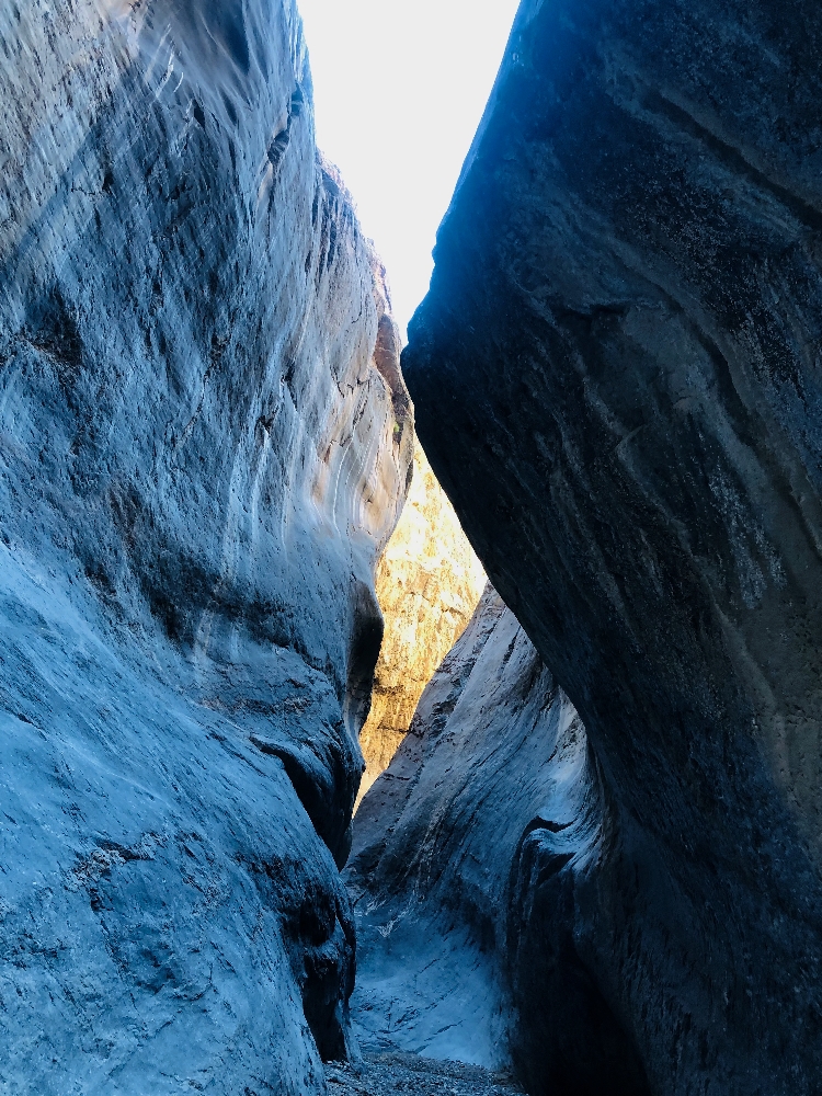
Narrows in Lower Marble Canyon. Photo by Carole Jacobs.
Hungry for more? Read about Death Valley’s dark skies.
4. Cottonwood Canyon, Death Valley Wilderness
Cottonwood and Lower Marble Canyons are next-door neighbors and connected by a 30-mile backpacking loop trail. But despite their proximity, they could be on different planets.
From the fork in the road to Lower Marble, the road to Cottonwood threads 10.4 miles through sky-high walls of dark gray dolomite before dead-ending at the foot of Cottonwood Creek.
I blinked at the mirage, which could have dropped in from The Everglades.
The 4-mile trail followed the beautiful desert stream as it fed a series of creeks, swamps, and three shimmering oases lined with grasses, wildflowers, and towering willow.
In between the shady, moist oases were bright, barren expanses of desert that made for hallucinatory hiking. One minute, the trail threaded through a gloomy grove where the trees were cloaked in hanging grape vine. The next, it emerged into the blinding light of desert solitaire.
Directions: From the Stovepipe Wells general store, follow the dirt road past the campground and airport and continue 21 miles to Cottonwood Canyon, following the signs.
Lodging: Stovepipe Wells is located twenty-one miles from the canyon.

The road into Cottonwood. Photo courtesy Pixabay.
5. Golden Canyon, Black Mountains
The 4 ½ mile Golden Canyon Lower Gluch Trail began cheerily enough. It swept up through golden hills and chasms; passed Red Cathedral, a 400-foot cliff that glowed in the dusk; and winded up to Zabriskie Point, an iconic viewpoint overlooking vast panoramas of undulating canyons and badlands that turn myriad shades of gold at sunset. Then the trail descended into Lower Gulch, where winding narrow canyons conjured up a surreal, alien world. In fact, several sci-fi movies were filmed here, including Star Wars. The narrowing canyon suddenly dead-ended at a 25-foot dry waterfall. For a panicked minute, I feared my only recourse was to turn around and retrace my steps in the dark. Fortunately, a footpath curled up and around the falls, out of the canyon, and into the reassuring twilight of Planet Earth.
Directions: The Golden Canyon Trailhead is located 2 miles south of CA-190 on Badwater Road in Death Valley National Park.
Lodging: The Ranch at Death Valley is located about 3 miles from Golden Canyon. Flush from a recent multi- million- dollar face lift, the historic resort now has a beautiful town square with towering date palms and mission California architecture. In addition to a hotel and swank casitas, there’s a new restaurant, an old-fashioned ice cream parlor and coffee bar, a large general store with souvenirs and groceries, a saloon with a Wild West theme, a spring-fed pool, sports court, children’s playground, horseback riding, carriage rides, jeep rentals, and Furnace Creek Golf Course, the lowest elevation course in the U.S.

The Ranch at Furnace Creek. Photo by Carole Jacobs.
6. Perdido Canyon, Hidden Valley
The trail through this canyon-sized time machine takes you to the end of time. I followed it into a wide gorge dotted with Joshua trees and surrounded by steep, high walls that on closer inspection, bore tiny fossils called Horn corrals. The shell is made from lime the animal secretes in conjunction with the seasons. Like tree rings, the grooves tell the age of the coral. In the 1960s, geologists discovered by counting the grooves that about four hundred million years ago, the year had 395 days because the earth was spinning faster and completing a revolution in 22 hours. This discovery confirmed scientific theories that the earth’s spin was continually slowing due to friction from the Earth’s surface and ocean tides. In four hundred million years, the slowing has only added two hours to our day. But in time, the earth will eventually slow to the point that it will stop spinning altogether. At that point, one hemisphere will freeze, the other will fry—and earth will no longer be the habitable place it is today.
Directions: From Stovepipe Wells, head northwest toward CA-190 to Scotty’s Castle Rd for forty miles and continue on Ubehebe Crater Rd for twenty-nine miles to Perdido Canyon.
Lodging: Stovepipe Wells
To learn more about Death Valley, visit this website.
-Story by Carole Jacobs, Health and Fitness Editor, RealFoodTraveler.com









0 Comments